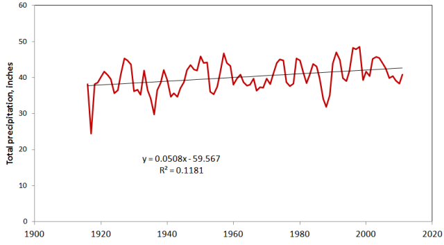
Rainfall and temperature records for Cincinnati in the period 1916 to 1982 were made at the Abbe Observatory on Lafayette Circle in Clifton, just uphill from the former path of the Miami & Erie Canal. This was the only commemoratively-named station in the National Weather Service in honor of its first director Cleveland Abbe, who had begun his career in Cincinnati. In the figure below, rainfall records from Lunken Airport, which are closely similar in years where they overlapped, are spliced onto the Abbe records to give a continuous record, presented as a three-year moving average. Note the long-term rising trend with wet and dry cycles about 6 years each.

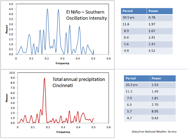
A time series analysis of this pattern, using the program PAST, reveals periods of 5.7 and 6.6 years for these cycles. El Nino -- Southern Oscillation intensities have the same two periods, but at different powers. It appears likely that ENSO events have considerable influence over rainfall patterns in the Ohio Valley, but that other controls are also important. See El Nino and Cincinnati Weather.

Related webpages
Time series for Cincinnati rainfall
Rainfall history from groundwater levels