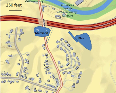
Samples were studied from two locations: a wetland formerly known as Blair Pond, and a dry area on either side of Clifton Ave once known as Mummert's Pond. Data reported here are from Mummert's Pond.
Locations of trench and auger samples (see also Mill Creek sediments)
1. Samples from Mummert Pond, east side (taken Fall 2010, Spring 2011)
At the beginning of the project in October 2010, a trench was excavated to the water table at a depth of 48 inches (122 cm) and 5 grab samples taken at roughly 25 cm intervals. The samples showed a steady increase upwards in heavy metals, presumably a reflection of increasing industrialization of the area along the canal. The topmost sample does not show this enrichment, but is texturally distinct from the underlying sediment -- coarser and more poorly sorted -- and so likely represents later fill or slope wash.

In the spring, auger samples were taken from a few feet to the north (Core 3a), to a depth of 3 meters. Probing with steel rods found refusal at about 5 meters, so the full thickness of the pond fill was likely not sampled. [Link to data in excel format.]
2. Samples from Mummert's Pond, west side (taken Fall 2011)
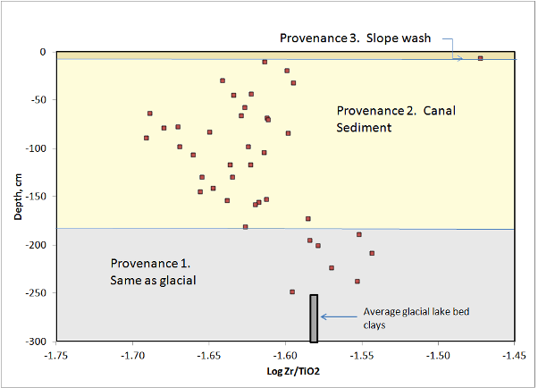
Also in fall 2011 a new trench was opened in the former Mummert Pond, west side of Clifton Ave. Continuous sampling of 5cm3 blocks was conducted from the surface to the water table at -160 cm. A nearby auger hole was extended to -250 cm. Combined data for these samples show trends in elements resistant to alteration such as Ti and Zr that suggest three different types of sediment with three different sources ("provenances") are present. The three also differ in grain size.

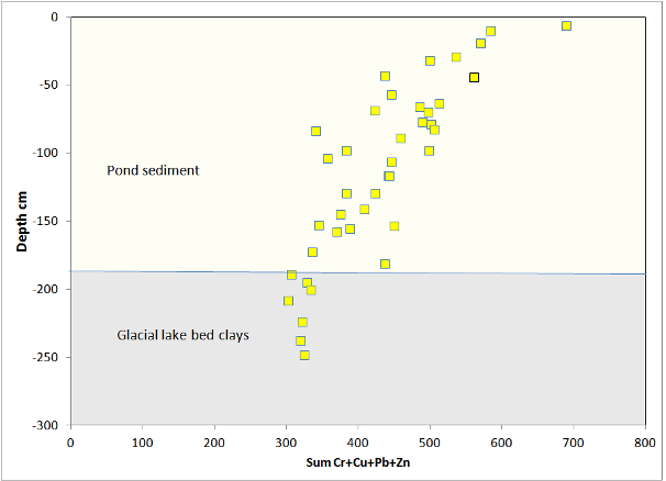
The profile, for the samples included in "provenance 2", shows the same upward increase in heavy metals as on the east side of the road.

The flat profile at close to background levels for samples below 180 cm confirms that this is different material, most likely lake clays because of their softness in the probe profile.
Mill Creek alluvium also shows an upward increase in heavy metals, so this is a general trend for the Mill Creek Valley, and presumably records increasing discharges of metals to the water and air as industry developed along Mill Creek and along the canal.Related webpages
