

Geological Foundations of the Greater Cincinnati Area of SW Ohio, N Kentucky, and SE Indiana
The geologic underpinning of Cincinnati consists of old Ordovician bedrock, which contains the world-famous fossils of the area, a capping of glacial deposits, much younger but still ancient in human terms, and thick, modern river-bank deposits along both the major rivers and many smaller creeks. All three are involved in slope failures
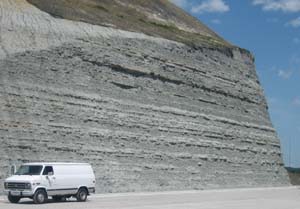
The Ordovician bedrock has layers of hard gray  limestone alternating with soft gray shale. One thick rock unit, the Kope Formation, is mostly shale and therefore is particularly prone to failure. This formation is continuous across the area and underlies most of the hillsides along major streams. Soil that forms on the Kope is a mixture of sticky clay and fragments and slabs of limestone. When wet, it moves down slope, sometimes creeping slowly, sometimes sliding rapidly: an unconsolidated mantle always poised to move downhill.
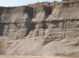
The glacial deposits are more variable and their distribution is harder to predict. One reason for this complexity is that they were deposited at sever al different times: the Wisconsinin (19.000 years ago); the Illinoisian (125,000 years ago); and a set of pre-Illinoisian deposits (Fig. 3 and 4). These glaciers all stopped in the vicinity of Cincinnati and left a complex series of ice-laid and water-laid deposits. These include till (an unsorted mixture of clay and silt with scattered pebbles and even boulders), outwash sands and gravels, which are mined for construction aggregate in many stream valleys, and lake bed clays, the culprit in many damaging landslides.
The riverbank deposits are lower in clay, consisting mostly of sandy silts. They make very attractive land for farming and for real estate development, but are prone to flooding. Furthermore erosion on the outside bends of the stream is common and leads to bank-failure landslides.

